Morrissey Boulevard: Still Stuck Between Floodwaters and Frustration – Can it be fixed?

The Boston Globe does a deep dive on Morrissey Boulevard.
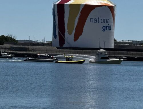
If you’ve ever sat in traffic—or floated through a rainstorm—on Morrissey Boulevard, you know this stretch of road has been a headache for decades. Between flooding, crazy traffic, and long-delayed construction promises, it’s been the ultimate “we’ll get to it soon” project for city and state officials.
Morrissey Boulevard stands as one of the clearest signs of how climate change is already impacting Boston. The century-old roadway that hugs Malibu Beach near Savin Hill wasn’t built for today’s rising seas — and it shows. During king tides and stronger, more frequent storms, sections of Morrissey are now regularly swallowed by water, turning commutes into detours and reminding us just how vulnerable our coastline has become.
According to a Boston Globe feature, over the past 30 years, multiple plans have been floated (no pun intended) to fix it—some meant to tame the tides, others to untangle the traffic. Each time, though, the project has hit roadblocks: endless red tape, agency disagreements, and a price tag that’s ballooned to around $300 million for just three miles of roadway.
Now, Boston and two state agencies are back at it again, looking for a way to either raise the road or build protections against rising seas. And the clock is ticking. By 2050, parts of Morrissey could be under as much as 10 feet of water during major storms, according to state climate models. Yikes.
So can it be fixed? Back in November of 2023, the first meeting of a new Morrissey Boulevard Commission kicked off the process of drafting a plan to renovate the decades-old roadway. Included in this plan is raising Morrissey Blvd’s elevation to avoid future floods and modifying its layout to improve traffic flow for cars, public transit, bikes, and pedestrians.
In the spring, planners published a report offered several options, from raising the road several feet to adding a sea wall. Proposals on the table ranged from reducing the number of car lanes to adding dedicated bike paths and safer pedestrian walkways. One idea even called for building a berm — a raised barrier that could double as both flood protection and a scenic waterfront park for the community.
Plus there’s the cost of this mammoth project. According to the Globe, The central section of the project alone — which contains most of the flood resilience measures — will cost around $141 million. The rundown Beades Bridge needs to be replaced and could cost more than $100 million. Then lets not forget the redesigning Kosciuszko Circle, aka the rotary from hell could cost $92 million.
You can read more about this whole messy and expensive situation here.
Maureen Dahill is the editor of Caught in Southie and a lifelong resident of South Boston sometimes mistaken for a yuppie. Co-host of Caught Up, storyteller, lover of red wine and binge watching TV series. Mrs. Peter G. Follow her @MaureenCaught.